The 162-km (100-mile) hike known as The Dingle Way in County Kerry has been placed 34th in a Top 50 List of most beautiful hiking trails in the world.
This news item contain affiliate links and I may earn compensation when you click on the links at no additional cost to you.
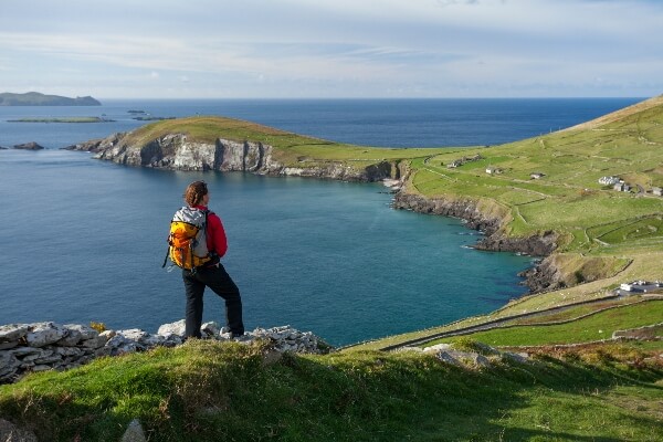
The trail, which is located along the southwest coast of Ireland along the Wild Atlantic Way, is part of the breathtaking Dingle Peninsula.
The placement is the result of a survey conducted by the European outdoor footwear brand Zalando, which set out to discover the world’s most photographed hiking trails by accessing Instagram data.
Almost 5 million Instagram hashtags were assessed, along with the many images associated with each route.
That number was then divided by the length of the hike to uncover which one had the most photos taken per mile.
Top of the list is Peru’s Inca Trail, with the popular European pilgrimage route, the Camino de Santiago in Spain coming in second place.
According to Zalando’s results, there were 96 photos per mile associated with the County Kerry hiking trail.
By clicking on the Amazon link below, I may earn a small commission from the Amazon Associates Program if you decide to buy something on the site. However, you will not incur any additional costs by doing so.
In 2021, The Dingle Way was included in Lonely Planet’s list of “Epic Hikes in Europe,” together with other popular hiking trails like the Wicklow Way and the Causeway Coast Way in Northern Ireland.
Discover The Dingle Way
The Dingle Way, a circular route, starts and ends in the town of Tralee.
Being one of over 30 long-distance walking trails in Ireland, it’s fair to say that to complete the entire hike would take approximately 8 to 9 days and require a good level of fitness.

Since the trail is broken down into eight stages, there’s really no need to do the entire route unless you want to of course.
Taking about 6 to 8 hours each day, every stop along the entire route is marked by a village or town, which makes for convenient pit stops.
Below is a bit more detail on the various stages of the trail.
Stages of The Dingle Way
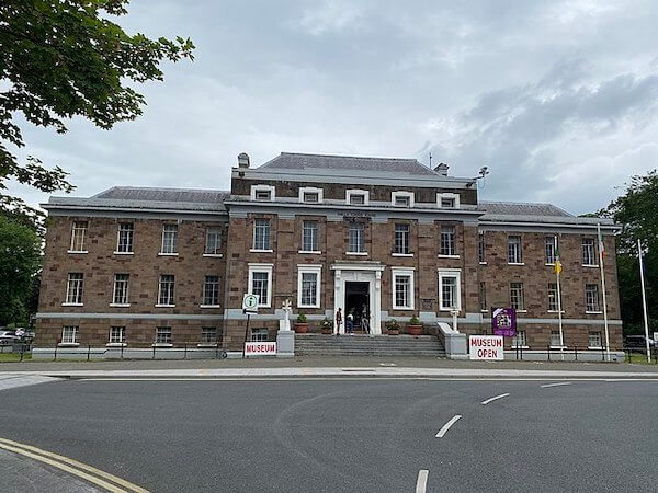
Stage 1: Tralee Town to Camp Village
This 11.7-mile/19-km trail is considered challenging and takes hikers close to 5 hours to complete.
Visitors will encounter some lovely countryside along the way, including some beautiful coastal views.
This stage of the trail is popular with backpackers and campers.
Directions: This trek starts and finishes at the Kerry County Museum. There is a sign alongside the railing nearby that directs hikers to the trail head.
Stage 2: Camp Village to Annascaul Village
This moderate stage of The Dingle Way takes visitors approximately 5 to 7 hours, with only one steep climb.
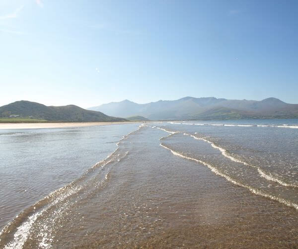
The 11-mile/18-km walking route follows rural roads and climbs to the saddle between the Corrin and Knockbrack Mountains, then gently descends to the other side of the Dingle Peninsula.
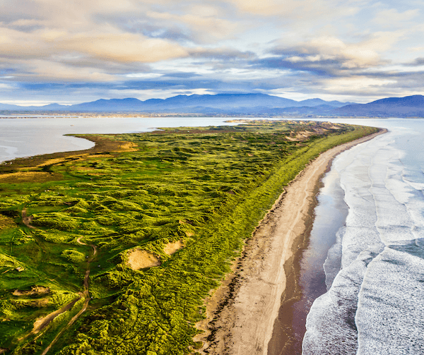
Great views of Inch Beach can be seen at this point in the hike.
It continues with views of Lough Annascaul farther ahead and some interesting standing stones to observe nearby.
Directions: Follow the directions in this link to Camp Village from Tralee if traveling by car.
Read More: Where to Go Walking in Ireland: 10 Walks that Showcase Ireland’s Real Beauty
Stage 3: Annascaul to Dingle
This moderately strenuous 13.6-mile/22-km part of The Dingle Way takes hikers about 7-9 hours.
Most of it is on quiet back roads but visitors should expect a few steady uphill climbs, with spectacular views as their reward, including Dingle Bay, the Iveragh Peninsula and the mountains of the Dingle Peninsula.
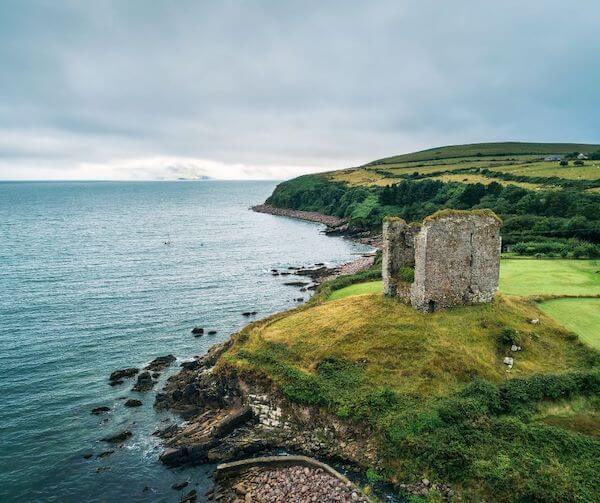
Some of the notable attractions along the way include the 16th-century Minard Castle, one of only three castles built by the Fitzgerald clan in the region.
Along the trail, hikers can expect to reach the foothills of two local mountains, Croaghskearda and An Cnapán Mór.
Directions: The driving directions from Tralee to Annascaul can be found here.
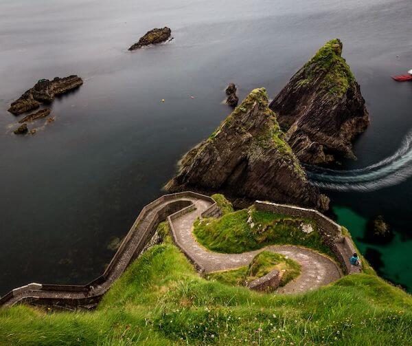
Stage 4: Dingle to Dunquin
This 12.42-mile/20-km is a moderate hike, the majority of which is on quiet back roads as well as a few steep climbs to spectacular views. It takes about 4-6 hours to finish.

The route follows the R559 for less than a mile/1 kilometer, ending up on a lovely beach walk in Ventry.
On the remainder of this stage, hikers will see some ancient beehive huts and beautiful views of Dingle Bay, the Blasket Islands and the rugged Kerry coastline. This stage of The Dingle Way ends at Dunquin Pier.
Directions: The directions to this route from Tralee can be found at this Google Map link.
Get Wifi in Ireland with Wifi Candy – take 10% off with code IOB10
Stage 5: Dunquin to Ballycurrane
This 14-mile/23-km walk takes hikers about 5 to 8 hours to complete.
Hikers leaving Dunquin should prepare themselves for a brisk uphill walk that begins Stage 5 of The Dingle Way and eventually turns into a gravel path that rises to 120 meters/393 feet above sea level.
The picturesque Clogher Beach can be seen along the way as the trail gives walkers an amazing view of the North Atlantic waves crashing below the cliffs.
Lots of beautiful coastline to enjoy on this stretch, including Wine Strand, as well as Murreagh and Feohanag in the heart of the West Kerry Gaeltacht (Irish-speaking region).
Directions: Follow these directions to Dunquin from Tralee.
Stage 6: Ballycurrane to Cloghane
This 13-mile/21-km part of the trek takes hikers about 6-9 hours to complete.
This stage involves a stiff climb to the shoulder of Mount Brandon, where an ancient ogham stone marker and an inscribed cross, known as Cosán Na Naomh can be found.

Hikers need to be careful on the descent especially if the ground is wet. The next part of the journey takes them through Brandon Village, which makes for a great stopping off point.
Leaving Brandon Pier, hikers can expect about 6 more kilometers/4 miles before finally making it to the village of Cloghane.
Directions: From Tralee, follow these directions to Ballycurrane and the beginning of Stage 6.
Try an AllTrail Trial for Free
Stage 7: Cloghane to Castlegregory
This 16-mile/26-km hike, which takes about 5-6 hours to complete, begins on a quiet road out of Cloghane, with hikers eventually reaching the coast after about 3.5 kilometers/2 miles.
This is a much easier stage, with hikers finding themselves on sandy beach trails, especially between Fermoyle and Castlegregory.
The Magharee Islands can be seen from this area as hikers make their way along one of Ireland’s longest beaches, Fermoyle Strand.
Toward the end of this stage, hikers will make their way around Scraggane Bay before eventually reaching Castlegregory, about 8 kilometers/5 miles away.
Directions: From Tralee, follow these driving directions.
Stage 8: Castlegregory to Tralee
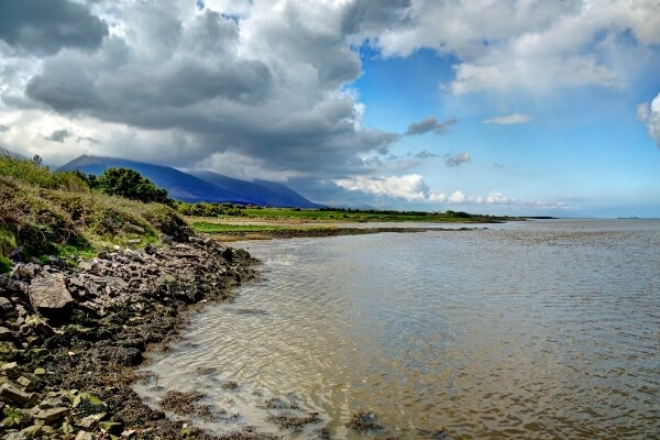
This 17-mile/28-km hike, which takes about 8-9 hours takes hikers on a stunning walking route comprised of sandy beaches and on to the slopes of the Slieve Mish Mountains before ending back in Tralee.
There is really one steep climb on this leg of The Dingle Way, with the remaining trek on quiet country roads and stretches of bogland.
Hikers can expect great views of Tralee Bay, Derrymore Island, Fenit and Blennerville, Ireland’s only working windmill.
Directions: Follow these directions from Tralee to Castlegregory.
Save on Ireland Tours with Tourradar in 2025
Diverse Landscapes
Perhaps the single reason why The Dingle Way is such a popular trail is the different landscapes that it covers.
Hikers will find everything from fabulous mountain views of Slieve Mish and Mount Brandon (Ireland’s second-highest mountain) to crashing North Atlantic waves at Slea Head.

The trail also includes plenty of pastoral farmland, golden beaches as well as archaeological sites that include standing stones, ancient Ogham stones, and a variety of beehive huts, which are common in this area.
Archaeological Sites to Explore
Perhaps the most well-known of the region’s archaeological sites is the Gallarus Oratory, an early Christian stone church that has a distinctive appearance, making it look like an upturned boat.
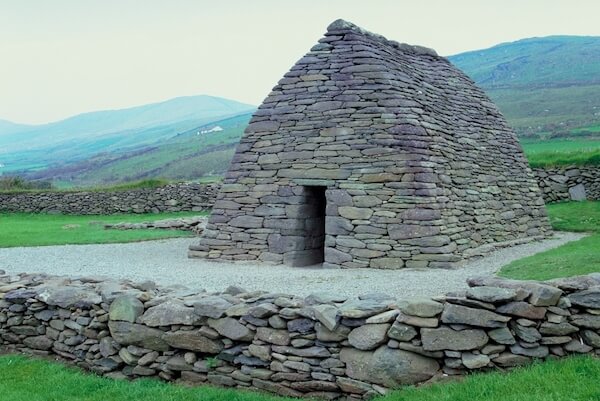
Archaeologists have determined that the oratory was built in a way similar to that of the Neolithic tomb at Newgrange.
By clicking on the Amazon link below, I may earn a small commission from the Amazon Associates Program if you decide to buy something on the site. However, you will not incur any additional costs by doing so.
Pike Trail Waterproof Leg Gaiters are Perfect for Hiking in Remote Environments
Shrine to Local Man and Antarctic Explorer
The South Pole Inn is another popular stopping-off point on the route.
The friendly pub located in the village of Annascaul is where Antarctic explorer Thomas Crean returned after his trip to Antarctica with Ernest Shackleton and others.

A native of the village, Crean opened the pub in 1920, having served many years in the British Navy and exploring the far reaches of Antarctica.
Crean never spoke about his exploits, and he didn’t put them down on paper either.
In this shrine to the local man, visitors will find plenty of information on his life and worldwide exploits.