Walking trails in Sligo and Donegal that have been chosen for their beauty and rich cultural heritage are now part of an exciting EU project called Trail Gazers.
This news item and page contain affiliate links and I may earn compensation when you click on the links at no additional cost to you.
The initiative, which is funded by the European Regional Development Fund, aims to help rural communities showcase the walks and trails that they have, creating something that both visitors and locals can safely navigate and enjoy.
The walks in County Sligo include The Queen Maeve Trail on Knocknarea and the Killaspugbrone Looped Walk.
In Donegal, an 8-km (4.97 miles) looped path, part of the Inch Wildfowl Reserve in an area known as Inch Levels, will be the focus of the project.
The three walking trails in Sligo and Donegal are among a total of eight trails across other parts of Europe.
Some of the plans for the initiative include the creation of smartphone apps that would enhance the experience for walkers.
In Donegal, an app called “Lost Stories and Folklore of the Trails” will highlight old stories, folklore, and fables from the area around Inch Levels that will be of benefit to all, with information on key points of interest along the way.
You can download both the Apple and Android version of the app online.
SLIGO TRAILS
If you’re in the Sligo area, be sure to check out these two outstanding walks that really highlight the beauty of Yeats County.
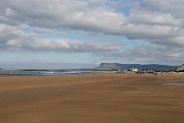
The Queen Maeve Trail Knocknarea
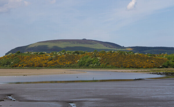
Knocknarea, the reputed burial place of Queen Maeve of Connaught, dominates the County Sligo landscape.
So, it makes sense that many visitors to the county might want to climb to the top so they can get up close to the burial mound and view the breathtaking scenery from the mountain’s summit.
The trail is about 6 km (3.72 miles).
It is considered strenuous, so wear the appropriate footwear, dress in layers and bring plenty of water and snacks if you need them.
You’ll begin your adventure at the parking lot on the R292 just outside Strandhill (opposite the Sligo Rugby Football Club).
The trail includes over 500 wooden steps that will take you gradually up the mountain.
Along the way, you’ll go through a pine forest, eventually coming to a raised boardwalk or “bog bridge” that leads to the top of the mountain.
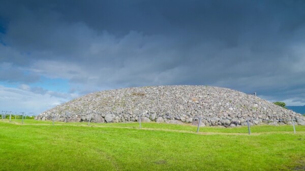
Once you reach the top, do not climb on the cairn.
Considered to be the largest burial tomb in Ireland outside of the Brú na Bóinne complex that includes Newgrange in County Meath, this one measures an impressive 55 meters (180 feet) wide by 10 meters high (33 feet).
Archaeologists believe it was constructed around 3,400 B.C.
There are a number of smaller tombs on the summit of Knocknarea that appear to face the Carrowmore passage tomb site, also in County Sligo.
A visit to the Carrowmore Interpretive Centre is recommended as you’ll get a better idea of the history of the landscape in this part of Sligo and the ancient people who lived there.
On a clear day, you’ll see not just Sligo Bay below, but the Ox Mountains range, Lough Gill, and Slieve League in Co. Donegal, even as far away as Croagh Patrick in Co. Mayo, Ireland’s holy mountain.
Killaspugbrone Looped Walk
This is a remote coastal walk that starts at the Strandhill promenade.
You’ll enjoy a variety of coastal habitats, including sand dunes, salt marshes, and pine woodland.
The most prominent attraction on the route is the early Christian site known as the Killaspugbrone Church, reputed to have been a monastic settlement located at the tip of the Coolera Peninsula.
It dates from between 1150 and 1220 and is believed to have been founded by St. Patrick.

You’ll also see Coney Island in the distance.
It can be accessed by boat from the pier at Rosses Point or by car from the nearby Cummeen Strand when the tide is out.
DONEGAL TRAIL
There’s certainly no shortage of beautiful landscapes in Co. Donegal, but one section of the county on the Inishowen Peninsula has been chosen for this exciting project.
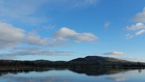
Inch Wildfowl Reserve Looped Path, Inch Levels
This remote reserve is located about 12 km (7.45 miles) from Derry and 26 km (16 miles) from Letterkenny.
The area is known as one of Ireland’s premier wetlands and as such is designated a Special Protection Area (SPA) under the European Union Birds Directive.

It is situated on the eastern shores of Lough Swilly.
The looped pathway, which was once part of the Derry to Letterkenny railway line, is popular with locals who use it for walking, running, and cycling.
There is seating at various points along the trail from where you can view the beautiful scenery and the many migratory birds, including ducks, swans, and geese.
Some of them are known to fly from as far away as South Africa to nest in this beautiful spot.
There are a number of “bird hides” along the path so you can get a good look at the migratory species.
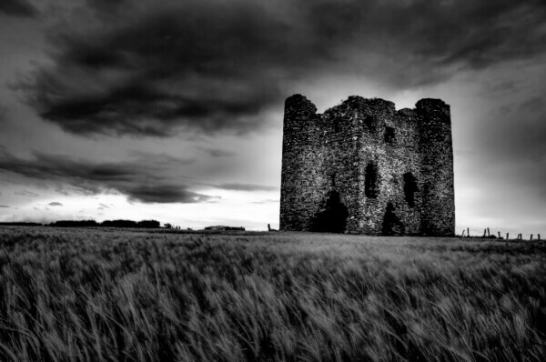
Some of the heritage sites close by include Inch Castle, located on the southern tip of Inch Island.
It was built in 1430 by the Gaelic Chieftain Neachtain O’Donnell.
Burt Castle, about a 9-minute drive away, was a traditional stronghold of the O’Doherty clan. The design of the castle, built during the reign of King Henry VIII, was influenced by Scottish castles of the time.
Read More: Strandhill Named Best Health and Well-Being Destination